Day 16- Tuesday, June 10- 92.5 K
Day 17- Wednesday, June11-Weather break
Day 18- Thursday, June 12- Rest Day
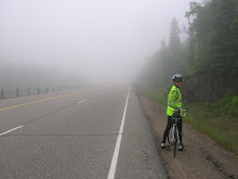
As you recall, there was some indication of ice on our tent. Was this an indication of what was to come??? The first thing we noticed was the wide shoulder on this Alberta highway. We came out of the foothills with some headwind until we reached the Pincher Creek Husky Station, heading to Fort Macleod. As we headed out back onto the road the eastern headwind felt like a gale. Carol's friend Chris couldn't wait until we reached her home in Fort Macleod and drove out to search for us. We normally cruise at about 20 km per hour, but the conditions slowed us to more like 13 kmh.
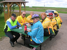
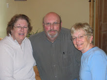
What a heartfelt welcome we received from Terry Malone and Christine McKnight. Terry (manager of Head-Smashed-In Buffalo Jump) organized an incredible series of experiences at the Jump for us. From a buffalo stew dinner to sleeping in the lodge (instead of teepees since the weather was too vile) to listening to the Blackfoot interpreters-Stan Nowlton, Peigan; Trevor Prairie Chicken, Blackfoot and Sioux; and Josh Crow Shoe, Peigan.
During the dark and stormy days we wiled away many hours at a new local bakery/cafe called Rahn's, where we recouped all the calories we had burned. Today was the most relaxing we have had here. We rested, wandered about town and got our laundry up to date. During all this time we have had free run of Chris and Terry's house. We would like to thank both of them for the fabulous welcome and many, many kindnesses they have shown us.
We are now ready to face whatever the elements offer us. Tomorrow, come hell or whatever, we are heading at least as far as Lethbridge or beyond. We have to get that far because there doesn't seem to be anything except blades of grass between here and there. By Adele and Carol
Subscribe to:
Post Comments (Atom)


.JPG)


.JPG)
.JPG)


.JPG)
.JPG)


.JPG)
1 comment:
Back here in "White Rose Country" (Yorkshire) We have been getting progress reports from David J. A headwind on the Prairies must be something to avoid! Still, the road between Fort Macleod and Lethbridge seems to be almost flat according to Google Earth. Is it easy rolling?
Google Earth (No I don't have shares in it) seems to confirm what you say about there being nothing of interest between FM and Lethbridge.
There's a famous "walker" of the North of England who wrote about the Yorkshire Dales, the English Lakeland Fells and so on, called Wainright. He wrote about his walk from Coast-to-coast here. His least favoured part of the walk was the boring, wide, flat bit between the highground of the Yorkshire Dales and the Moors on the East coast. I guess you all have now reached something like this - to be endured! Let's hope you start to get the tail wind back!
Post a Comment